Running the Scenic Crest of the Sauratown Mountains
If you are driving south on North Carolina’s Highway 77, right where the road begins the drop down the face of the Blue Ridge, and you gaze off to the east on a clear day, you can see three distinctive mountains rising out of the Piedmont on an east-west alignment. These are the Sauratown Mountains. They are not a part of the Blue Ridge, and are not much over 2,500 feet in height—but they are prominent nonetheless because they loom 1,500 feet or so above the surrounding flatlands. Pilot Mountain is the closest, about thirty miles away.
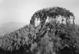
The Saura Indians called it “Jomeokee,” the great guide or pilot. Because of its distinctive rock cap summit, Pilot Mountain has served as a landmark for countless travelers for many centuries. Hanging Rock is the mountain farthest east and Sauratown Mountain is the one in between. If you are in a hurry or on business you keep driving past Mt.
Airy and on to Winston-Salem. But if you are of an adventuresome bent, you can’t help but wonder what it would be like to run or hike from the top of Pilot Mountain over Sauratown Mountain and finally stop at the summit of Hanging Rock. From the top of the Blue Ridge, it doesn’t look to be too far of a trek. It’s August 26. 8:30 in the morning.
The Big Pinnacle, the rock cap which sits atop Pilot Mountain, is awash in mist. I’m on the trail which encircles the Big Pinnacle, leaning casually against the exposed rock. I’m ready to run. My road crew synchronizes her watch and nods at my exhortations concerning the great photo opportunity before her.
Me with Pilot Mountain in the background, of course. I glance over my shoulder and peer through the mist eastward toward Hanging Rock. Can’t see it—too foggy. At the signal, I push off from the Pinnacle and slouch down the rocky trail.
In only about 100 yards I reach the parking lot near the summit. My road crew has already fired up the sag wagon and taken off. I jog the curving, banked roadway 2.5 miles down hill to the entrance to Pilot Mountain State Park. From here I will be following the Sauratown Trail, along some roads and trails on private and public lands, over Sauratown Mountain and ultimately to Hanging Rock State Park.
I have my Sauratown Trail map and directions in a plastic baggie and I study both items as
I idle down a deserted country road. I wonder vaguely about country folk hereabouts and whether their friendly doggies will be tied up or roaming. Guess I’ll find out. Despite numerous turns on little back roads, the directions are good and I don’t lose the trail for another three miles.
But then I take an educated guess and turn right when I should have gone left. I jog about a mile and find myself in the little town of Pinnacle—which is not where I’m supposed to be. No sag wagon in sight so there is nothing for it but to retrace my route. I pass the point of my wrong turn and soon bump into an actual trail in the woods and, miraculously as it seems to me, a sign that says “Sauratown Trail.” Must be the place, eh?
The trail does turn out to be real— narrow and rarely traveled, yes, but still I never get lost again after I get on this trail. The main problem with this trail, however, is that apparently no one has hiked it all summer. Every twenty feet or so there are huge sticky, gooey spider webs spanning the trail. I run through every one.
If you do the math you will realize that there is a huge sticky wad of spider webs accumulating on my head and chest as I run over this trail of several miles, not to mention the annoyed spiders that occasionally come along for the ride. I do my best to perspire profusely to wash away the slimy webs. I ford the West Prong of the Little Yadkin River getting my feet wet. I emerge on a road just minutes before my loyal road crew was going to give up on me—or so she said.
Energized by food and drink, I enter the woods on the other side of the road and head up the steep trail on the side of Sauratown Mountain. Half way up I realize I am a might beat. Wet shoes, spider webs, trail still headed up—I am over half-way aren’t I? The map isn’t really very clear on this point.
But the sag wagon has moved on so it’s no use turning back. At the top of Sauratown Mountain the trail ends and I’m back on a dirt road. My wonderful road crew is looking ever more beautiful every time I see her and her car stopped by the side of the road. But I can’t tarry.
The long dirt road down Sauratown Mountain has the worst dogs. But mostly they just hurry out to investigate, scare the bejesus out of me, make faces and a lot of noise. The route winds around on a few more roads and then turns back into the woods and I pass a sign that says I have entered Hanging Rock State Park. All right!
That’s a relief because I am getting busted. But I’m not just about there. It is a long stretch on the park trails, Huckleberry Ridge and Moore’s Knob, until I reach the lake and bathhouse at Hanging Rock (but at least these trails had been recently hiked so no more spider webs across the trial!). The drop-dead gorgeous road crew is there in the parking lot with a syrupy soft drink and several kind words.
Excellent drink. Excellent woman. She looks at me pityingly. I’m guessing I don’t look so good.
She says that I don’t really have to climb the rest of the way to the top of Hanging Rock. But we both know that, actually, I do. So we walk to the last trail head and start up. It isn’t so much further.
When I scramble over the rocky outcrop and reach the very highest point of the Rock that Hangs, the official road crew timepiece pronounces: 5 hours 18 minutes and 5 seconds. A time to beat for all you serious adventurers out there. But if you try it, don’t miss that left turn near Pinnacle. And on the trails run behind someone taller than you if you can.
It helps with those spider webs. More information: Pilot Mountain State Park, Route 3, Box 21, Pinnacle, NC 27043; Telephone: office (336) 325-2355; fax (336) 325-2751; Directions: Located twenty-five miles northwest of Winston-Salem on US 52. Hanging Rock State Park, PO Box 278, Danbury NC 27016; Telephone: office (336) 593-8480; fax (336) 593-9166; Directions: Located in Stokes County, four miles northwest of Danbury. The park entrance is on Moore’s Spring Road (SR 1001), which lies between NC 8/89 east of the park and NC 66 west of the park.
For a map of each state park and its trails go to http://www.ils.unc.edu/parkproject/ Maps.html and click on the appropriate map. For the Sauratown Trail, see Allen De Hart’s North Carolina Hiking Trails, 2nd Edition, 1988, at pages 438-440. 76m